Weather Alert in Wisconsin
Air Quality Alert issued May 29 at 4:34PM CDT by NWS Duluth MN
AREAS AFFECTED: Douglas; Bayfield; Ashland; Iron; Burnett; Washburn; Sawyer; Price
DESCRIPTION: The Wisconsin Department of Natural Resources has issued an Air Quality Advisory for the following counties: Ashland, Bayfield, Burnett, Douglas, Iron, Price, Sawyer, Washburn. WHAT...The PM2.5 AQI is expected to reach the Unhealthy for Sensitive Groups level. WHERE...All of Wisconsin WHEN...6 am Friday, May 30 until 6 am Saturday, May 31 Precautionary/Preparedness Actions: Sensitive groups: Make outdoor activities shorter and less intense. Its OK to be active outdoors but take more breaks. Watch for symptoms such as coughing or shortness of breath. People with asthma: Follow your asthma action plan and keep quick relief medicine handy. People with heart disease: Symptoms such as palpitations, shortness of breath, or unusual fatigue may indicate a serious problem. If you have any of these, contact your health care provider. Additional Details: Air quality will degrade from north to south on Friday as Canadian wildfire smoke pushes in ahead of a cold front. Unhealthy for Sensitive Groups (USG) AQI (Orange category) is expected for much of the state, with the potential to reach Unhealthy AQI (Red category). Areas to the southwest (mostly along the Mississippi River valley) will have the best chance to remain in Moderate AQI on Friday. The front will move into northeast Wisconsin Friday evening and begin clearing the air from northeast to southwest. However, this will also push smoke further south and west, and an additional Air Quality Advisory may be needed on Saturday for western areas if PM2.5 concentrations remain high enough. For more information on current air quality, please see: https://airquality.wi.gov
INSTRUCTION: N/A
Want more detail? Get the Complete 7 Day and Night Detailed Forecast!
Current U.S. National Radar--Current
The Current National Weather Radar is shown below with a UTC Time (subtract 5 hours from UTC to get Eastern Time).

National Weather Forecast--Current
The Current National Weather Forecast and National Weather Map are shown below.

National Weather Forecast for Tomorrow
Tomorrow National Weather Forecast and Tomorrow National Weather Map are show below.

North America Water Vapor (Moisture)
This map shows recent moisture content over North America. Bright and colored areas show high moisture (ie, clouds); brown indicates very little moisture present; black indicates no moisture.

Weather Topic: What are Cirrocumulus Clouds?
Home - Education - Cloud Types - Cirrocumulus Clouds
 Next Topic: Cirrostratus Clouds
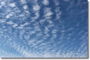
Cirrocumulus clouds form at high altitudes (usually around 5 km)
and have distinguishing characteristics displayed in a fine layer of
small cloud patches. These small cloud patches are sometimes referred to as
"cloudlets" in relation to the whole cloud formation.
Cirrocumulus clouds are formed from ice crystals and water droplets. Often, the
water droplets in the cloud freeze into ice crystals and the cloud becomes a
cirrostratus cloud. Because of this common occurrence, cirrocumulus cloud
formations generally pass rapidly.
Next Topic: Cirrostratus Clouds
Weather Topic: What are Cirrus Clouds?
Home - Education - Cloud Types - Cirrus Clouds
 Next Topic: Condensation
Cirrus clouds are high-level clouds that occur above 20,000 feet
and are composed mainly of ice crystals.
They are thin and wispy in appearance.
What do they indicate?
They are often the first sign of an approaching storm.
Next Topic: Condensation
Current conditions powered by WeatherAPI.com


